Comprehensive Guide to Weather Radar Maps
The Importance of Weather Radar Maps
Weather radar maps are critical tools for meteorologists and the general public alike. They provide real-time information on precipitation, storm systems, and other atmospheric phenomena. Understanding how to read and interpret these maps is essential for predicting weather events and making informed decisions for safety and planning. As weather extremes increase in frequency, the relevance of accurate and timely weather information cannot be overstated.
How Weather Radar Works
Weather radar operates by emitting radio waves into the atmosphere. These waves bounce off precipitation particles, such as raindrops or snowflakes. The radar system then measures the time taken for the signal to return, along with the intensity of the bounce. This data is processed and displayed as a radar map, illustrating areas of rainfall, storm development, and intensity levels. Modern weather radar can also detect velocity, allowing meteorologists to identify wind patterns and potential tornadoes.
Recent Developments in Weather Radar Technology
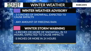
Advancements in radar technology have significantly enhanced our ability to monitor weather patterns. For example, dual-polarization radar technology provides a more detailed analysis of precipitation types, distinguishing between rain, sleet, and snow. This technology has proven invaluable, especially during winter storms where accurate forecasts can save lives and property. Additionally, integrating radar data with satellite imagery offers a comprehensive view of weather systems and their movement across regions.
The Role of Weather Radar Maps in Storm Preparation
As severe weather events become more common, the role of weather radar maps in storm preparation is increasingly crucial. Local meteorological services use weather radar to issue timely alerts for tornadoes, hurricanes, and severe thunderstorms. These alerts provide residents with critical information to seek shelter or evacuate when necessary. Furthermore, many mobile weather applications offer access to live radar maps, enabling users to monitor conditions in real-time from their smartphones.
Conclusion
Weather radar maps play an essential role in understanding and predicting weather patterns. Their accuracy and detail empower meteorologists and everyday individuals with the necessary information to navigate and prepare for weather events. As technology evolves, these radar systems will continue to improve, making accurate weather forecasting more accessible and reliable. Staying informed about how to interpret weather radar maps can make a significant difference in safety during unexpected weather conditions.